South Ionian Sea

South Ionian Sea

In sharp contrast to the hilly green islands, the coastline is lined with tall, jagged mountains, bright turquoise waters and white sandy beaches. This is the South Ionian Sea.

The 10 most beautiful areas in this region

The yachting conditions resemble those in Croatia, with short distances between the islands, protected seas between large islands, a number of smaller islands, and plenty of natural bays and harbours. Compared to Croatia, the sea is warmer, there are almost no marinas but there are numerous city ports where you can berth for free or for a nominal sum, and then there are the hearty, smiling people. The area of the islands between Lefkada and Zakynthos is the best area in Greece for novice yachtsmen or families with children.


  1. Katsiki Beach—Egremni on the western coastline of Lefkada
  2. Vasiliki Beach—a paradise for surfers and kite-surfers
  3. Island of Meganisi—bays to the north of the island
  4. Kastos Harbour—on the island of Kastos
  5. One House Bay—on the island of Atokos
  6. Vathi Harbour—on the island of Ithaca
  7. Fiskardo Harbour—on the island of Kefalonia
  8. Myrtos Beach and other beaches—western coastline of Cephalonia
  9. Smuggler´s Cove with beach and shipwreck—northwest of Zakynthos
  10. Laganas Bay with turtle beach—south of Zakynthos
jonske more

Yachting areas

The Greek gods gave yachtsmen a gift and it was called the Southern Ionian Sea. The islands of Lefkada, Cephalonia and Zakynthos create a natural barrier protecting the sea from all fierce winds and large waves towards the mainland. A sheltered stretch of sea 80 NM in length is thus created with dozens of little islands that you can sail for months and always find something new to discover. This combination of green islands with many bays and beaches, warm seas, old town harbours, and historical monuments creates an irresistible mix of experiences. The southern Ionian Sea spreads out along the western coastline of the Peloponnese all the way to the distant island of Kithera, which yachtsmen only set out for in spring or autumn for sports sailing.

 Weather and climatic conditions

In terms of the weather, the northern part of this area is almost identical to the North Ionian Sea. In the southern part, the wind turns S to SW and dies down somewhat later in the afternoon. The best time for sailing south is in the afternoon when a steady wind blows with a force of 4–5 on the Beaufort scale (BFT). You will sail comfortably and quickly with a nice wind on the quarter. On the other hand, we recommend sailing north in the morning and later morning, before the winds start to really blow. In the afternoon you will be sailing upwind or with a sharp crosswind. Nice, but it can make for somewhat uncomfortable sailing.

weather

Islands

Lefkada

Directly off the coast of mainland Greece, not far from Corfu Island, is the fourth largest island in the Ionian Sea, Lefkada. It is the only island that in addition to air and water routes you can also reach by land. This is made possible by two bridges that connect Lefkada with the mainland. The largest entry point for sailing yachts is the local city pier or marina.

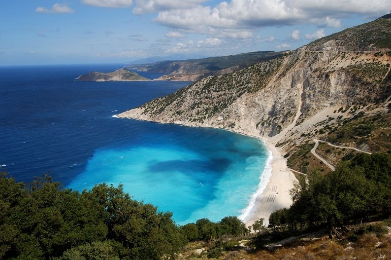
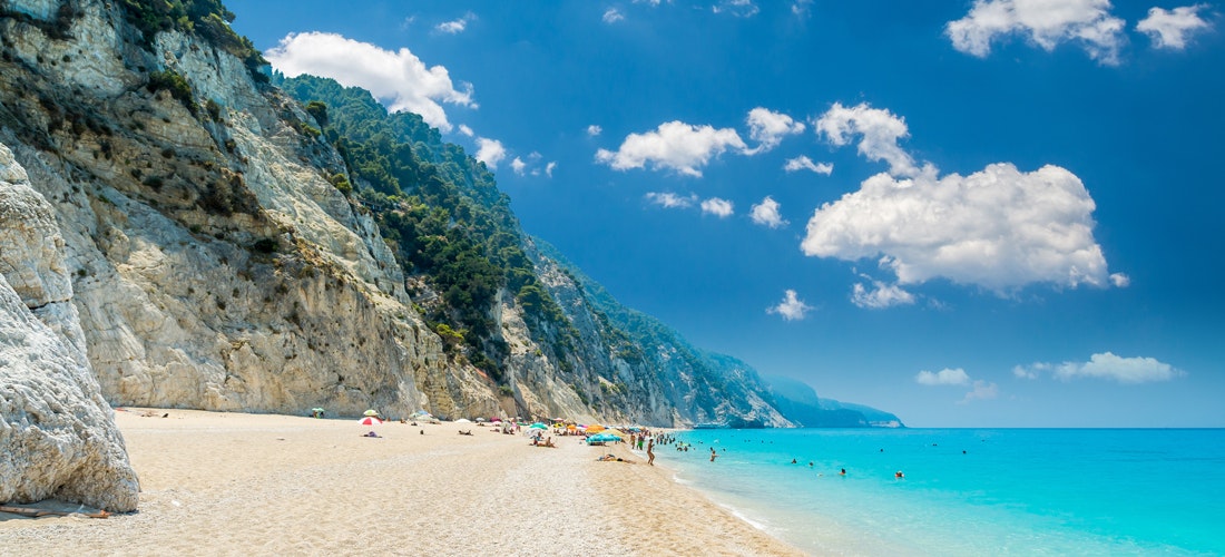
Despite being a tourist destination, Lefkada has maintained its natural character and tends not to be as overcrowded as some of the other islands. Beautiful white beaches lie in beautiful contrast to the turquoise sea, with deep green vegetation on the cliffs along the coast and breathtaking sunsets that are a visual delight. Lefkada offers it all.

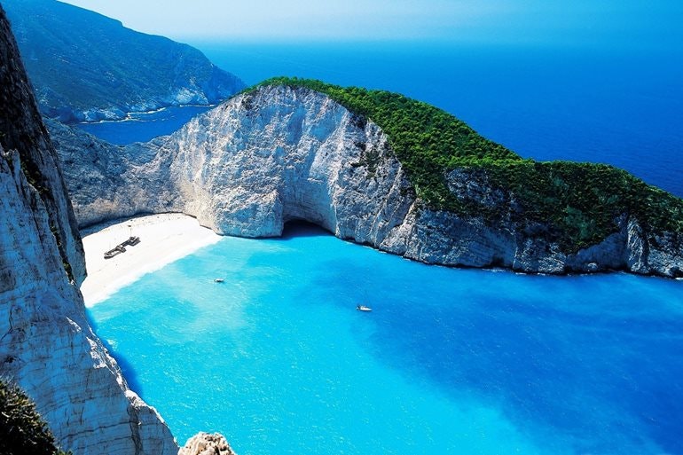
Mountains spread out for 300 km square, sloping down to the fertile lowlands and seashore. The whole island is typified by its fertility and lush vegetation, which is the result of abundant rainfall, especially in winter and spring. You can see all the traditional Greek plants, such as olive trees, plane trees, pines, grapevines, cypress trees, and a variety of colourful flora. Along the edges of the island are the most beautiful beaches in all of Greece with fine white sand, bright pebbles and crystal clear waters, beaches such as Porto Katsiki or Egremni.

The limestone cliffs along the coast create a perfect backdrop and are responsible for the light blue colour of the seawater. Sometimes, however, they make it difficult to get on the beach at all, but in most places there are suitable means for accessing paradise, either by boat or on foot down the long staircases on the rocky slopes.


It is not very well known that Lefkada is not essentially, an island, since it was not until the 6th century BC that the Corinthians separated it from the mainland with a 20 m wide channel. It still exists today and is complemented by a bridge and road that raises every hour to allow larger ships to pass. Like most cities in the area, the city of Lefkada was destroyed in 1953 by a huge earthquake and its rapid reconstruction was not ideally executed. The waterfront, however, is very pleasant. The true Greek atmosphere that will take you back centuries in time, can be experienced further inland, where you will find original mountain villages that time has forgotten. You can see the undisturbed life of local people, often still attired in traditional village clothing.


Lefkada Town Pier

Anchoring is on the northeastern or southern side of town. Because of the pier extending from the end of the southern side, it is better to land, bows-to. The South Pier has the benefit of pulling you away from the pier in the overwhelming NW wind, its disadvantage being that dust from the city blows directly into the boat. On the NE side you are pulled towards the pier, which is usually not a problem unless you are dragging the anchor. However, the bottom is covered with sticky mud, so the anchor should hold fast. Water and fuel are available on the pier and nearby, there is a shipyard which is handy for any repairs. Near the pier there are several very well-stocked supermarkets.


Lefkada Marina

Lefkada Marina is located directly to the south of the city pier with an entrance at its southern part. The depth here is from 2.5 to 4 m and offers 434 berths. In summer due to the NW wind, the waters may be slightly restless and some berths may be affected by southern winds. The marina has a complete infrastructure, including water, electricity, workshops and a mini-market. Bigger stores can be found in the city.

It can be said that Lefkada is still a market town with little use for tourism. It is a small town and a harbour with narrow streets and colourful houses full of the sounds of traditional Greek music and the fragrance of flowers drifting down from people’s balconies. The town does not hibernate in winter, even when most of the tourists have left. The main busy thoroughfare, Odos Dorpfeld, is named after the German archaeologist Wilhelm Dorpfeld (1853–1940) who discovered many surprising facts about the history of the city during his excavations. The local residents hold him in high regard. Some of his discoveries are exhibited in the small Museum of Archaeology. More interesting, however, is the local Museum of Folk Traditions where exact models of some of Dorpfeld’s excavations and impressive photos of the city before the 1953 earthquake are housed. At the northern end of the canal, you cannot overlook the beautiful ruins of the Sánta Mávra Fortress from the 14th century.

Meganissi  

The island of Meganissi, with the famous Papanikolis cave, is near the Greek island of Lefkada and one of the few smaller islands that is permanently populated. There are roughly 1000 people living here in three local villages: Katomeri, Spartohori, and Vatha. Thanks to its beautiful sandy beaches and several sea caves, tourism has developed rapidly in recent years, especially in the summer season.

The coast is richly rugged, lined with rocks and green hills, crystal clear waters, and sand with pebbles that are pleasantly warm. Olive trees and grape vines grow on the slopes peacefully, the sun's rays are reflected in the azure waters and the air smells of the sea and flowers. The western part of the island is flat and agricultural crops prosper, while the eastern part of Meganissi is hilly, the highest mountain being Megas Birnos. The local climate and weather is the same as on Lefkada.

Atokos

Atokos, a heaven on Earth, untouched by humans, is situated among the Echinades Islands (Echinus means, sea urchin) near the coastline of Acarnania.

Who could resist the calm, turquoise waters, the white cliffs at One Bay House, and the dense vegetation covering the island? Atokos is a private island owned by a Greek millionaire. As there are no anchoring restrictions, you are free to savour the beauty of the island.

Ithaca

"Every visitor is a citizen of Ithaca" declares the symbolic sign in the harbour. Ithaca was home to the mythical Odysseus and is also a type of symbol for the mother country we all wish to return to. Its history stretches all the way back to the period around 4000 BC and it experienced a great boom at the time of the Mycenaean civilisation, thanks to its lively trade with the mainland and Italy. The island impresses us as mysterious from afar. It is tall, rocky, and often shrouded in mist. Arriving in Ithaca harbour is perhaps even more impressive. You sail in with your boat into a tall bay similar to a fjord with the ruins of two French forts dating back to 1805, which protected the harbour from above at the foot of the mountains. You pass by the small island of Lazaretto which in 1668 the Venetians transformed into a quarantine facility, later serving as a prison and today home only to a chapel hidden among the trees.


Ithaca Town Breakwater

You will recognise this picturesque harbour by its conspicuous bell tower and the road chiselled into the rocks of the Korini mountains. You can anchor either bows-to or stern-to on the western side below the ferry area, or you can land stern-to on the outer part of the breakwater. You can also anchor at the protruding part of the breakwater at the beginning of the bay. The quay has been widened at the northeastern part to allow yachts to anchor stern-to or bows-to and not encroach on the spaces intended for fishermen. It becomes deep very quickly, so you will need to drop anchor at a depth of 10–15 metres. The bottom is muddy everywhere and has thick grass, so your anchor will not find a perfect hold. The prevailing winds blow into the bay, so make sure to check that your anchor has a good hold. As soon as the winds abate after sunset, you usually don’t have to worry anymore. You can anchor at the beginning of the bay at a depth of 2–5 m. Although the anchorage is open to blowing winds, it is a safe anchorage—but only if your anchor holds well. In harbour, most services can be found at the northern breakwater, including a mini tanker with fuel and boxes for water and electricity. The repair shops here are only able to deal with basic problems, but you can easily buy provisions. You might also rent a car or scooter—something which is highly recommended.

Dangers: there are often gusts in the direction of the prevailing winds in Aetou Bay.

The island is a truly tranquil location, where instead of visiting archaeological digs, you can enjoy beautiful scenery and genuine Greek atmosphere in peace and quiet. Several locations on the island are associated with episodes from Homer's Odyssey, although in fact very few remains have been found here proving whether Ithaca was actually the site of Odysseus’ palace. In any case, this is a very pleasant place. 3 km from the capital is the Cave of Nymphs, where Odysseus allegedly hid his treasure. Another reason for enjoying a walk could be the Spring of Arethusa, which is 11 km away. In the town itself is the now traditional Archaeological Museum with Mycenaean remains as well as the Museum of Folk Traditions, which has a unique Japanese issue of the Odyssey dating back to 1600 on display. Of great interest is the local Taxiarchos church with an icon of the Crucifixion of Christ, which was allegedly painted by El Greco when he was young. The most likely location of Odysseus’ Palace seems to be the small hill called Pelikatas on the edge of town not far from the smaller Archaeological Museum, where the remains of a building and a terracotta mask bearing the inscription Odysseus were found.

Cephalonia

Cephalonia is separated from Ithaca by a strait only a few miles wide. Landing at this most extensive Ionian island, you will truly find everything here, from picturesque harbours that are familiar from advertising posters, to mountains and the monasteries hidden among them. In 1953, a strong earthquake destroyed most of the island, including the capital of Argostoli where only a few old houses remain.

Argostoli Marina

In 2014, this marina had still not been completed, so there were no toilets or running water. Overall, this facility is in a relatively rundown state. Nevertheless, the marina is functional, with 254 spacious berths, well protected from the prevailing winds. The town breakwater would probably be a better choice.

Argostoli Town Breakwater

You will recognise it from the western side near the Ák Yero-Gómbos lighthouse, while from the east you will see a conspicuous white hotel on Ák Pelagia.

Beware of the cliffed coastline leading SE from Ák Pelagia and the cliff heading W from Ák Áy Nikolaos. In the afternoon breeze, winds in summer can reach 5–6 BFT.

Anchoring is in the traditional manner, either stern-to or bows-to, south of the ferry pier or at the northern end of the western pier. The sea floor is muddy and anchors hold well. Water is available directly at the pier and fuel can be delivered by mini-tanker, the fuel pump being located south of the yacht pier near the mini-market. At the harbour, you will even find repair shops and stores with yachting equipment of all kinds, including electrical supplies.

In recent years, the town has been transformed into an almost elegant location, with a main boulevard full of fragrant bakeries, cosy cafés, and expensive boutiques. There are plenty of tavernas on the shore, with a magnificent view of the bay, spanned by the seemingly fragile Drapanos Bridge, which even survived the long-ago earthquake. If you are interested in how life was in the city after the earthquake, you can visit the Historical and Folklore Museum of the Corgialenos Library. Here you will find photographs, a collection of furniture, clothing and paintings from this time. Among the natural attractions of the island are the immensely interesting Drogarati Caves with a huge underground hall, where the perfect acoustics allow concerts to be held in the summer. Then there are the Mellisani Caves north of the town of Sami that hide a saltwater lake.


Zakynthos

Heading south from Cephalonia, you will arrive at the famous island of Zakynthos. Offering not only beautiful beaches and an amazing capital, but also the opportunity to see the loggerhead sea turtle. These turtles once nested in abundance in Laganas Bay, but tourism has not been kind to them as they battle tourists for the golden sand where they lay their eggs. Despite this, Zakynthos is a Mediterranean haven for these turtles. Zakynthos is also the island of the poet Dionysios Solomos, author of the Greek national anthem, the "Hymn to Liberty". The local museum has a piece of wood from the tree under which Solomos composed the poem in May 1823.


Zakynthos Harbour

The harbour is conspicuous from the north due to the hills dominated by Mount Skopio (520 m), which from a distance, together with the plains to the east looks like a separate island.

Caution: watch out for the Ifalos Dimitris reef, the unlit mooring buoys by the fuel pipeline, and of course, the ferries.

Anchor at the NE or NW part of the breakwater, bows-to or stern-to. The sea floor is muddy and your anchor will hold excellently. Berths are well sheltered from prevailing winds, it only being sometimes impossible to moor at the NW breakwater during strong southerly winds. You will find water and electricity at the NE breakwater. A mini tanker can provide fuel and you will find fuel stations at several of the local quays. You can stock up on supplies in town.

The town of Zakynthos was also completely destroyed during the earthquake of 1953, but has been very tastefully rebuilt in the original Venetian spirit. Behind the beautiful waterfront, you will find attractive shopping streets. In an alleged act of "divine intervention", the magnificent cathedral dating back to 1925 was not destroyed by the earthquake, this being consecrated to St Dionysios, the patron saint of the island. It is remarkable that the church and chapel of the Moni tis Panagias tis Anafronitrias monastery, where St Dionysios was abbot, escaped the destruction unscathed. The remains of this saint are kept in the Chapel of Agios Nikolaos sto Molo, which stands at the other end of the harbour on Plateia Solomou Square. As the island was at the centre of the Ionian school of painting in the 17th–18th centuries, the exhibition at the Byzantine Museum is incredibly interesting.