Dodecanese

Dodecanese

Enjoy this enigmatic tract in Greek waters with untouched corners alive with rich traditions and rustic resorts.

The 10 most beautiful areas in this region

The Dodecanese cruise spoils you for choices of where to go. You can cruise to the Greek islands, some with incredible isolation or ahead, to the coast of Asia Minor. Cruising on the open sea will be accompanied by strong, large waves during the summer. Cruising along the Turkish coast will also be with a stronger wind but without waves. The alternation of Greek and Turkish ports offers a fascinating comparison of two different cultures and the experience of friendly people on both sides. Compared to Croatia, the sea is more open, the distance between larger islands greater, marinas are less frequent and the prices for ports is considerably lower.

  1. Rhodes Harbour—the old town
  2. Chalki
  3. Symi Harbour
  4. Palon Marina—Island of Nysiros
  5. Kos Harbour—the old town
  6. Island of Astipalea
  7. Island of Pserimos
  8. Vathi Bay—Island of Kalymnos
  9. Island of Lipsi (Leipsoi)
  10. Pandeli Harbour—Leros
dodekanesy

About Dodecanese


This arid, but extremely attractive archipelago for yachtsmen includes, not 12, as the name suggests, but 14 main islands, three smaller inhabited and many uninhabited islands. It is the southernmost Greek archipelago, and so is the hottest. If you want to see the local flora in full bloom, set sail in the spring; in high season there is very little water here and the islands dry up completely by autumn. Probably the most forested islands are Kos and Rhodes, where several natural water springs are located. Like most of the Greek islands, the Dodecanese mountain peaks of the Aegean Plain are also submerged by the sea.  


Looking back in history, the prosperity of this area has always been centred around Rhodes, which dominated trade from ancient times up to the 19th century, and now controls the newly established trade of tourism. The origins of local military architecture are very interesting. Surprisingly it is not Venetian or Genoan, but was created by the Knights of St John (the Knights Hospitaller), who disseminated the style through the entire area. However, their occupation also ensured a lively trade with the Venetians. In 1522, the Knights succumbed to the Turks, who remained on the islands until 100 years ago. Although the Dodecanese did not join Greece until 1947, the character of the local buildings is no less Greek than the Cyclades. Turkish dominance is barely noticeable here, in spite of the fact the island of Kastellorizo lies just 3 km from the Turkish border.  

kos

Weather in the Dodecanese

The predominant air element here is the ubiquitous Meltemi. They begin blowing intermittently in June, and reach their full strength from July to September, blowing once again intermittently in October. In the summer months they blow mostly at a force of 2–4 on the Beaufort scale (BFT), but can even reach 7 BFT. Even if it does not blow every day, you can sometimes enjoy it for up to 10 days in a row, mostly from the NW to W. During such times, it is especially strong on the leeward sides of islands, where unpleasant gusting may occur. This mainly applies to Patmos, Kos, Nisyros, Tilos, Karapathos and Astypalaia. On the relatively open area between Astypalaia and Karpathos, the sea tends to be very rough if the Meltemi blows for many consecutive days. In winter, the prevailing wind turns SE, but winds from the north or south can also arise. Although the Meltemi provides some relief, it is very hot here in the summer, and temperatures can regularly reach 35°C.

In summer, sailing is essentially against or with the Meltemi, which blows N-NW around Patmos through the islands to Rhodes, where it turns west in the direction around Rhodes. It may be a problem in summer to get to the north and the west. With a bit of luck, there is the possibility of embarking early in the morning when the wind is weaker, since in the afternoon the thermal component of the sea breeze begins, which is intensified by the Meltemi. If you want to reach the Cyclades, it is best to cross the Dodecanese as far north as possible and then bear away west. In the Cyclades, the Meltemi blows from the north, and heading west it turns NW. In spring and autumn, you will probably run into the southern winds in the Dodecanese region. If you plan to sail north from here, for example to the eastern Sporades, it is good to go out in spring or early summer, when the Meltemi are still not at their full strength.

Islands

Rhodes

Rhodes is the largest of the Dodecanese islands and the most active in terms of tourism. This is very true of the northern coastline, where one small town blends smoothly into the next, forming a band of little souvenir shops, bars, tavernas and hotels. Thanks to its size though, the island also offers some quieter corners. The capital city of Rhodes is fascinating, a mix of the old and the new. The medieval old town meanwhile, is a true gem of the Aegean Sea and was deservedly included in the UNESCO heritage list in 1988. The old town is often compared to Jerusalem and has provided a safe haven for its inhabitants since 408 BC, although its current appearance was shaped by the Knights of the Order of Saint John, who had occupied the area since 1306. The fortress at the top of the hill is truly majestic, known as The Palace of the Grandmasters, and you will also be overwhelmed by the Street of the Knights Odos Ippoton, which is unparalleled on the islands. The Street of the Knights has been looked after very carefully for centuries and is lined by the residences of knights from the Order of Saint John. It was here that the knights of different nationalities met and where their names originate—the Italian Residence, the English Residence and so on. Make sure to visit the Archaeological Museum located in the old hospital of the Order of Saint John dating back to 1440–1481. What to look out for here? Most certainly the impressive marble statue dating back to the 1st century BC, depicting Aphrodite of Rhodes. But there are many beautiful places in Rhodes and this is why we recommend that you find a good guide to help you really enjoy the city to the fullest.

Rhodes Marina

You will find the marina south of the old town. You anchor here on the eastern side, either bows-to or stern-to, or you can anchor in the middle. Around 300 boats fit here with a full range of amenities such as water, electricity, showers, and toilets.

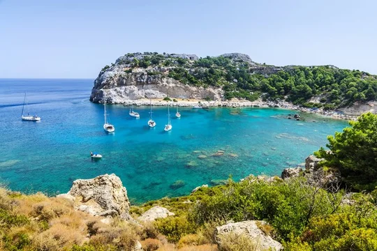
South of Rhodes, you will find the characteristic small town of Lindos with charming out-of-the-way lanes and whitewashed houses. Rising directly above the town to a height of 116 m and dating back as far as the 4th century BC, you will find the remains of the Temple of Athena Lindia, so highly venerated was she in ancient Greece that Alexander the Great himself, made a pilgrimage here.

Rhodes Harbour (Mandraki)

You can already see the city of Rhodes from afar, its huge hotels and many ferries making it quite conspicuous.

You must be careful of the shallows north of Milon lighthouse. Also, stay alert during strong southerly and easterly winds, as the entrance to the dock can be very choppy, but inside it is usually calm. The harbour is hopelessly busy during summer and charter companies protect their berths zealously. Yachts can anchor at the pontoon on the western side, where there are a few moorings, but anchors often cross here and the waters tend to be changeable. You can also anchor at the breakwater on the western side of Emborikós harbour, but the Meltemi and frequent manoeuvring of large ships make mooring here risky. Also be careful of the chain lying at the bottom 30 m from the breakwater. It is very easy to catch your anchor on this. The harbour is well sheltered from the Meltemi.


Symi

Symi is an island where more people lived than on Rhodes during its golden age between the 17th and 19th centuries. At that time, the island prospered thanks to the harvesting of sponges, which can be found practically everywhere along the coastline, and to boat building. From a distance the island looks harsh and desolate, but inland you will find pinewood areas. The great news for yachtsmen is that the coastline offers a lot of different nooks and crannies providing nice places to anchor. Just around the corner from the main harbour, you will find the Moni Taxiarchis Michail Panormitis Monastery, which although dating back only as far as the 18th century, offers many interesting things to see—for example an icon depicting the Archangel Michael, patron of the island of Symi and all sailors.

Symi harbour 

When sailing in, you will see a small town up on the ridge and the white church tower with a clock to the north of the bay. Anchor bows-to or stern-to at the north of the bay and leave free the space reserved for ferries. A harbour worker will usually direct you to the correct berth by whistling and gesturing. The depth in the harbour slopes steeply, so prepare a 12–20 m anchor, which may not hold perfectly. This is because the bottom is muddy and rocky. If the weather is good, you can anchor in Kharani Bay, where you should moor up to the mainland with a long line. The wake from passing ferries could cause problems.


Kos

Kos is one of the most fertile islands in the Dodecanese, covered with countless fruit trees laden with succulent fruits, vineyards and olive groves. This is also where Hippocrates, the philosopher and father of modern medicine was born. In Plateia Platanou, the square in the capital of Kos, there is said to be a plane tree that Hippocrates personally planted, and under whose canopy he lectured to his disciples. In reality, however, the tree is far too young at only around 2 000 years old. Not far from here you will discover the Knight’s Castle from the Knights of the Order of St John. The local Archeological museum, which displays a marble statue of Hippocrates made during the scholar’s lifetime is especially interesting. 6.5 km north of Kos lies the breathtaking archaeological site which is the ancient equivalent of today's fitness gyms, Asklepio, which was dedicated to the god Asclepius, patron of healing. And a little recommendation from us—if you go into the countryside, instead of wine, ask for its village equivalent, Dopio Krasi. It is light red, very strong, and reminiscent of sherry in terms of its flavour. 


Kos Marina

The marina lies about 800 m from the city harbour, to the southeast. The marina provides mooring lines, and a special dinghy will often guide you to your berth. The shelter here is very good, but try to tie up at the first two fingers near the entrance, where there is the least risk of rising waters in the northern winds. All moorings are equipped with electricity and offer blocks with toilets and a shower. 

Kos Harbour

You will recognize the Kos harbour from a distance by its fort on the southern side of the entrance, and also by the minaret in town. Anchor bows-to or stern-to at the pier on the eastern side of the bay. Here the harbour is well sheltered from the Meltemi, but in summer it tends to be quite full, so it is better to sail to the nearby marina. Other than that, you will find all of the essential services here.

Patmos

The island of Patmos holds special significance for the Greek Orthodox Church. In the year 95 AD, St John sailed here and saw a vision in the Cave of the Apocalypse, which he then dictated to his disciple. The cave can be visited in the beautiful church of Agia Anna, dating back to the year 1090. Just two years earlier, a monastery had been built there. This island accepts visitors with open arms, while preserving its original magic and, last but not least, its calming influence on the spirit. The local beaches are particularly remarkable, including the mountain scenery that beckons the restless yachtsman to go hiking. Mount Prasino is very attractive, it's the highest mountain on the island, reaching 775 m above sea level, from where it abruptly descends into the Aegean Sea. The beautiful city of Patmos has traditionally been divided into two parts—the harbour at Skala below and fortified Chora above. From Skala up to Chora, a steep path takes you to spectacular old mansions, churches, chapels and monasteries. Don’t miss the beautiful cathedral of St John dating from 1088 and surrounded by ramparts to ward off marauding pirates. Between Skala and Chora lies the Monastery of the Apocalypse, with the famous slit through which God spoke to St John, as well as many beautiful frescoes and icons.

Patmos Harbor

You can see Patmos Harbor from afar, mainly due to the fort and the monastery up on the hill. The scattered rocks and islets near the port are also notable, not least because you need to take care navigating them. Anchoring is in the NW part of the bay, both bows-to and stern-to, however, anchoring stern-to is better due to the NW gusts of the Meltemi. The seafloor is an aggregate of sand, mud and grass and holds the anchor very well. Anchoring is possible near the mouth of the bay at a depth of 6–10 m. In Skala, you will find all the necessary services, including well-stocked shops with tools, taverns and shops.


Karpathos

On Karpathos, life continues in the old, traditional way, despite the newly built airport that transports many tourists to the island. After disembarking, you will find an incredible, rocky landscape with a high mountain ridge, the island’s highest mountain of Kalimni, towering an impressive 1 120 m. For those seeking the lesser-known corners of civilization, located on the eastern part of the island is the village of Olympus. It was founded in 1426 and has been practically cut off from the rest of civilization ever since, with men and women still dressing in traditional costumes. You can reach it after anchoring on the eastern side of the island and climbing up a steep slope along the ridge to 600 m above sea level. The mountain village of Aperi is equally outstanding, and was the capital of the island up to the end of the 19th century, and is said to be the richest per capita settlement in Greece. Many of the villagers moved to the United States, where they grew rich before returning home to the village. The gateway to the island is undeniably, its charming capital and Karpathos Harbour where fishermen still weave their nets in the traditional way and where you can enjoy a freshly caught, masterfully prepared fish for dinner.

Karpathos Harbour

From the distance you can see a cross on the island of Patella and the cupola to the north of the outdoor windbreak. Anchor bows or stern-to at a new jetty in the southwest part of the bay. Be careful of spring lines that yachtsmen occasionally stretch across the bay and also of the shallow depth. Meltemi gusts also blow across the jetty, causing waves. In the morning, the gusts blow from the N and NE. Watch out for swells ahead of the southern wind. If you hear a siren, do not fear, it is probably the parrot that lives on a balcony over Café Kárpathos.


Diving

Achata Arch, Karpathos

This impressive, yet only 2 m high arch is located roughly 500 m north of Achata beach on Karpathos. From one side, it is made up of a massive cliff which rises up from a depth of 20 m to approximately 5 m below the sea. The arch is even well visible from the surface, and as a bonus you will find it near a large, shallow cave.

The wreck of the Thor Star, Pserimos

The merchant ship, Thor Star was built in 1965 and abandoned in 1997 near the rocky island of Pserimos for reasons still unknown. The bow of the ship rests in very shallow waters, at a depth of about 5 m, so the dive is suitable even for complete beginners. The rest of the ship slopes deeper and deeper all the way to the main bridge, which has come to rest at a depth of 30 m. There is also amazing biodiversity in the surrounding area, many fish having camped right in the hull of the ship. Be prepared, you can meet tuna, snapper or pike here.


Seal’s Cave, Rhodes

This is an amazing and unique cave beginning directly at the surface of the sea and dropping to a depth of 20 m. And what makes this cave so unique? At high noon, rays of sunlight shine from above all the way to the bottom, creating glittering colours and reflections as well as fantastic visibility. At the bottom of the cave are passageways which you should be able to swim through and get back to the surface of the open sea.

Recommended sailing routes

For more details about routes and individual locations, click on the icon at the top left corner of the map.